
This week I learned about a great tool from the US EPA called EJSCREEN, which allows users to visualize and download data related to environmental justice. The US has a long history of environmental racism, including building highways through predominantly black neighborhoods and using former factory sites for low-income housing. Pollution and increased noise exposure… Continue reading EJSCREEN: a tool for visualizing Environmental Justice
Author: matcham2.0
New R package released today: cleanRfield
This fall I developed an R package with Filipe Matias from North Dakota State University. It just got publicly released on Github earlier this evening, and I'd really love if you all check it out here: https://github.com/filipematias23/cleanRfield Some features I'm particularly excited about include the automatic and manual field boundary delineation. There's also example code… Continue reading New R package released today: cleanRfield
R Cheat Sheets: ggplot2- Updated Blog Post
Note: the below was originally written and published in November 2018. I edited the post for clarity and added a few notes on accessing some learning resources in R Studio itself, but you can still find the original here. This month I'm making lots of graphs in R and wanted to share some of the… Continue reading R Cheat Sheets: ggplot2- Updated Blog Post
Publicly Available Data Sets for Learning and Teaching
Whether you're learning basic coding in R or mastering the intricacies of mixed-model ANOVAs in SAS, it helps to have some data to practice with. I frequently make up small data sets for this blog based on random number sequences or subsets of other data I've collected, but when I need larger data sets these… Continue reading Publicly Available Data Sets for Learning and Teaching
R Tutorial by Hasse Walum and Desirée de Leon
I came across this truly delightful introduction to R and summary statistics tutorial while reminding myself how to write functions in R. I was impressed by how Teacups, Giraffes, & Statistics covers R basics with clarity and specificity while being incredibly endearing. This was the first place I've seen interactive R windows on websites, and… Continue reading R Tutorial by Hasse Walum and Desirée de Leon
Averaging Plot Data in R– Updated Blog Post
Note: the below was originally written and published in January 2019. I edited the post for clarity and added a few notes on using the Tidyverse suite of packages to do summarize data in R, but you can still find the original here. Not an R user but need an efficient way to average plot… Continue reading Averaging Plot Data in R– Updated Blog Post
Data Structures in R
Before I learned R, I had previously only programmed in Matlab. Matlab and R have comparable options for data types and treat objects very similarly, but R, and specifically the Tidyverse, has this whole other vocabulary for data structures. Understanding the differences between matrices, data frames, and other data structures made learning R easier for… Continue reading Data Structures in R
Making Violin Plots
Last week I posted some tips for reading violin plots, and this week I decided to play around with making some of my own! I use box plots pretty regularly, so I first tried remaking one of my own box plots as a violin plot instead. Today I'm only going to share information about making… Continue reading Making Violin Plots
Reading Violin Plots
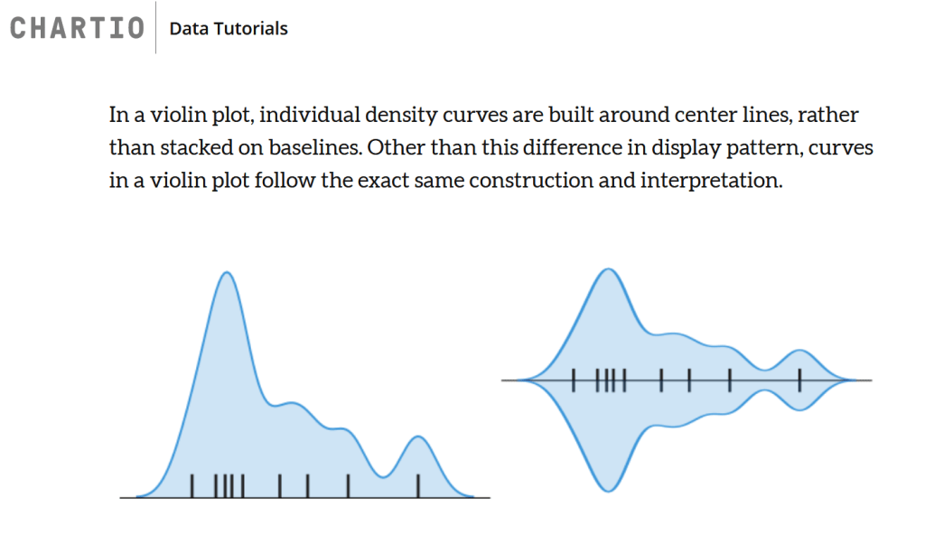
I have been seeing more violin plots recently and wanted to share some tips for reading all the information violin plots can show. At first glance they can be confusing and hard to read, but really, all the parts of a violin plot are probably something you've seen in another graph type before. First, what… Continue reading Reading Violin Plots
Two ANOVA Tutorials
Today I am going to continue highlighting resources I found helpful when studying for my prelims (which I successfully passed!). The last post on this topic was about blocking trials, and I'm glad I reviewed blocking and randomization for my exam since it was helpful in answering two of the questions on my exam. The… Continue reading Two ANOVA Tutorials
