
Satellite images have a wide variety of uses. They make a great backdrop for other maps and can give you an idea of land use in your area. The greenness in summer images can give you an idea of relative productivity. Bare ground photos taken when the ground is near field capacity can give you an indication of the drainage pattern or illuminate old tile lines.
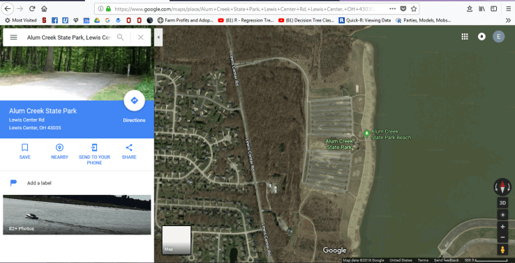
If you’re flexible about when your images were taken, there are many free options to get high quality satellite imagery. One of the best known is from Google Maps. Go to google.com/maps and use the search bar to find your area of interest (I’m using Alum Creek State Park).
 From there you can click on the “Satellite” button, highlighted to the left.
Below you can compare the satellite image to the original Google Street map.
 Google Maps is a great way to get a quick idea of the landscape in your area. You can take a screenshot to save an image, send maps to your phone, and search easily through their mobile app. Overall, it’s a great free tool to get started with satellite images.
If you’re a QGIS user, there’s a great way to get Google Maps, Google Satellite, and OSM/Stamen maps. Navigate to the Plugins tab on your main menu and got to “Manage and Install Plugins.” From there, download the “OpenLayers” plugin. This should add the “Web” tab to your main menu. Under the Web tab you can navigate to OpenLayers plugin and open all sorts of maps. Note that in QGIS, the Google Satellite layer has no road names or other markings– use Google Hybrid if you want a mixture of satellite images and standard Google Maps features. To the right is a quick screenshot of what this hybrid map looks like in the Alum Creek area.
One of the OpenLayers maps I’m most excited about lately is OpenCycle Map. I haven’t had a chance to play with it much yet, but it looks like a great resource for planning routes and finding new ways to move between trails.
Finally, Ohio has a great program to make high quality data publicly available. The Ohio Geographically Referenced Information Program, or OGRIP, has satellite images for the  whole state, as well as county maps, digital elevation models, and USGS maps. To get images, go to the Services/Data tab on the main menu, then navigate to “GEOhio Spatial Information Portal” and click “Ohio Spatial Data Infrastructure – Downloads.” From there you can use the highlighted search feature to find the place you’re interested in.
Along the left side of the map, you’ll see a zoom bar. If you zoom out to the county scale and click on a county, you’ll get some data options in the download menu (at the bottom). Note that the data available is for the county highlighted in blue. If you haven’t clicked a county or nothing is highlighted, this menu will be empty.
If you zoom in to the “tile” scale, you will get different data options. To make sure you get  the right tile, you can also turn the OSIP Imagery on as the map preview. This is how I usually get my satellite images. If I were most interested in the Alum Creek State Park parking lot, I would select tile N1835190 and download the Tiff option in the download menu.

Once you’ve downloaded your tiff file, you can open it in your photo viewer (see example to right) or load it into a GIS as raster data. Note that if you use it in a GIS, project it using the NAD83 (HARN) Ohio foot-based coordinate reference system (EPSG 3754). Beyond the fact that it’s free and easy to load into QGIS, I like using the OGRIP data because it comes with metadata specifying the resolution and date taken.
Satellite images have a wide range of uses for landowners and researchers. I hope this gives you a nice introduction to some free options to access this valuable information source.

[…] maps, and county or other political maps. You can learn more about the first type, aerial images, in one of my early blog posts about Google Satellite, OpenLayers for QGIS, and OGRIP. Today I’m going to share some data […]
LikeLike
[…] I’m continuing a series on sources of spatial data (see past posts on aerial images and DEMs). Soil maps are useful for all sorts of applications, like deciding where to place a trial […]
LikeLike